(click radar images to enlarge)
Starting yesterday afternoon around the Pee Dee River basin, thunderstorms began to quickly build. And as quickly as they built, they combined into a rather linear feature, indicative of the trough overhead. Montgomery County got in on the action early, as the storm later back-built to the south and southwest into a monster of two storm centers in Union, Anson, and Richmond Counties.
Including the Triad storms later, the slow-moving nature of the storms created flash-flood conditions from the inches of rain that fell in a relatively limited time space. Strong gusty winds added to the storm's fury that was in its own right beautiful to behold.
During one of the storms I chose to disconnect my computer, so I don't have actual radar grabs to show you...but I did have access early this morning to a graphic that depicts doppler-estimated rainfall, which you can key the color to the amount on the left-hand side. Town names are hard to see unless you enlarge the picture.
 Above is the storm total image taken at 1:45am from the Raleigh radar site, which has Montgomery County covered. Note the 'core' purples where 'fury' rained to the south...
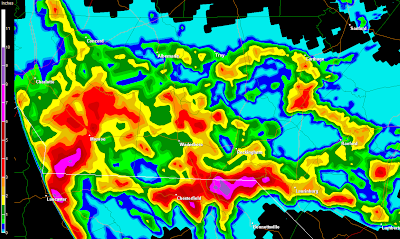
 This is the storm total graphic for the Forsyth/Stokes/Rockingham Counties storms late last night, again from the Raleigh NWS radar site...these areas had flash flood warnings posted until the wee hours of the morning.
Luckily it has finally died down, with the last thunderstorm in Caswell County moving NW and petering out just before sunrise. We'll have a chance to do it all again today...same set-up, too, where the actual rain chances aren't impressive, but what storms build will be. Best chances overall will be closer to the I-77 corridor.
We have another interesting player in the weather, as well...a honker of a wildfire in eastern NC near Albemarle Sound. Winds out of the east today will transport the smoke plume straight towards the Triangle and the Triad, helping create Code Orange conditions later today for unhealthy air quality.
A forecast link for the smoke plume, which I posted earlier, is not publicly accessible, so it seems. If I can find an alternate link, I'll post it again.
Not a pretty day in the nation's midsection...flooding rains continue to be a very serious issue, with a solid explosion of tornadoes yesterday. By clicking on the report image below, it will take you to that web page and you can look up individual reports by type and location.
Starting yesterday afternoon around the Pee Dee River basin, thunderstorms began to quickly build. And as quickly as they built, they combined into a rather linear feature, indicative of the trough overhead. Montgomery County got in on the action early, as the storm later back-built to the south and southwest into a monster of two storm centers in Union, Anson, and Richmond Counties.
Including the Triad storms later, the slow-moving nature of the storms created flash-flood conditions from the inches of rain that fell in a relatively limited time space. Strong gusty winds added to the storm's fury that was in its own right beautiful to behold.
During one of the storms I chose to disconnect my computer, so I don't have actual radar grabs to show you...but I did have access early this morning to a graphic that depicts doppler-estimated rainfall, which you can key the color to the amount on the left-hand side. Town names are hard to see unless you enlarge the picture.
 Above is the storm total image taken at 1:45am from the Raleigh radar site, which has Montgomery County covered. Note the 'core' purples where 'fury' rained to the south...
 This is the storm total graphic for the Forsyth/Stokes/Rockingham Counties storms late last night, again from the Raleigh NWS radar site...these areas had flash flood warnings posted until the wee hours of the morning.
Luckily it has finally died down, with the last thunderstorm in Caswell County moving NW and petering out just before sunrise. We'll have a chance to do it all again today...same set-up, too, where the actual rain chances aren't impressive, but what storms build will be. Best chances overall will be closer to the I-77 corridor.
We have another interesting player in the weather, as well...a honker of a wildfire in eastern NC near Albemarle Sound. Winds out of the east today will transport the smoke plume straight towards the Triangle and the Triad, helping create Code Orange conditions later today for unhealthy air quality.
A forecast link for the smoke plume, which I posted earlier, is not publicly accessible, so it seems. If I can find an alternate link, I'll post it again.
Not a pretty day in the nation's midsection...flooding rains continue to be a very serious issue, with a solid explosion of tornadoes yesterday. By clicking on the report image below, it will take you to that web page and you can look up individual reports by type and location.

No comments:
Post a Comment