(CLICK PICS TO ENLARGE)
(UPDATED AT 7:30AM)
(UPDATED AT 7:30AM)
The weather, that is...
The early Wednesday AM squall line was fun enough, what with the intense wind line and heavy downpours flying through...but the afternoon held a whole bag of tricks up its sleeve...
From the Triad's Tuesday's temps cemented in the 30s, the wedge broke Wednesday and by 2:30pm Piedmont Triad Airport had set it's high of 62 degrees for the day. Let's see now...suddenly warm air, full of moisture, strong SW winds ahead of a strong cold front with strong upper level winds and much colder air aloft soon to follow...ingredients for more "whatthe...?" in the weather department.
I had the radars on and saving images from time to time later in the afternoon, and they seemed interesting enough to pass along in a blog. The fun started in the mid afternoon when the Roanoke National Weather Service office put out a statement that gusty showers were moving along the VA/NC border and producing up to quarter inch hail. Not sleet. HAIL. Storm tops were barely 10,000 feet and there was quarter inch hail observed...all I could think was "whatthe...?" and "here we go!"
The radar imagery is nothing unusual, overall...but in the strange January mix of factors there was a lot more going on than met the eye. The first image is the basic Level 3 scan from the Raleigh radar somewhere around 5:45pm. The red box was the first of many severe thunderstorm warnings in (basically) eastern NC. The yellow blips to the left under and beside Greensboro were producing bursts of hail and heavy rain. And up to the VA border was a nicely coalescing line of cells that later started generating a good many lightning strokes:
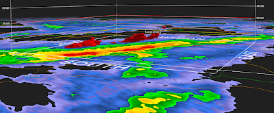
 Following is a volume scan of the yellow intensity levels of the line of storms heading up into Virginia along I-85....
 ...followed by the same scan with the yellow levels removed, revealing the more intense embedded red zones...
 By rotating the scan and looking at it from the SW as opposed to the SE, you get a clear look at how some of the storm tops are tilted in the direction the strong winds aloft are blowing...
 Though I'm in 3-D mode, I took this image from a bird's eye view onto the scan, this area just to the east of Raleigh around 6:45pm...
 I swung the view around to be perpendicular to the storm's path of travel, revealing a very pronounced tilt...
 ...and this is the important part to consider about a tilted storm: cells can't be thought of as being some perpendicular height. As seen in this case, the 'tower' that houses consolidated updraft and downdraft wind patterns has a pronounced angle to it. I call it the 'effective' height of the storm, the slanted line being significantly longer than the perpendicular one. Keep in mind there were numerous reports of pea-sized hail...and you have to have a certain distance for the storm draft channels to work their magic going up and down in the storm to coat pellets into hail stones.
 And so those puppies made stones, flying along with bursts of damaging surface winds as the plowed into eastern NC and up into SE VA. Below is a 'lit volume' scan of the various levels...you can get the idea that if you were 90 degrees to the right and this line heading right at you, it would look like a protruding wall heading to swallow you whole for supper! Thankfully, there was nothing tornadic in NC today, but the National Weather Service has plenty of LSRs (local storm reports) in the Tarheel state of winds in the 50-60mph range with lots o' damage from downed trees and such. Click on the map to follow to go to that page (probably only good for today, January 8, 2009):

 Last but not least were the first wave of snow showers popping into the NW NC mountains. Snow ends up looking like cauliflower on the radar, the cold air and frozen precipitation levels making for a swiss-cheesy sort of look and rounded segments...such scientific and scholarly terms use I...

-----------------------------------------
3 down and 2 to go this week. I think I've seen the screwiest the week has to offer (shouldn't have said that....!), with high hopes that Thursday and Friday will be a bit calmer and more straightforward to forecast. Models hint at a quick arctic blast moving in the middle of next week, but that will be back in Monte Montello's sandbox!
The early Wednesday AM squall line was fun enough, what with the intense wind line and heavy downpours flying through...but the afternoon held a whole bag of tricks up its sleeve...
From the Triad's Tuesday's temps cemented in the 30s, the wedge broke Wednesday and by 2:30pm Piedmont Triad Airport had set it's high of 62 degrees for the day. Let's see now...suddenly warm air, full of moisture, strong SW winds ahead of a strong cold front with strong upper level winds and much colder air aloft soon to follow...ingredients for more "whatthe...?" in the weather department.
I had the radars on and saving images from time to time later in the afternoon, and they seemed interesting enough to pass along in a blog. The fun started in the mid afternoon when the Roanoke National Weather Service office put out a statement that gusty showers were moving along the VA/NC border and producing up to quarter inch hail. Not sleet. HAIL. Storm tops were barely 10,000 feet and there was quarter inch hail observed...all I could think was "whatthe...?" and "here we go!"
The radar imagery is nothing unusual, overall...but in the strange January mix of factors there was a lot more going on than met the eye. The first image is the basic Level 3 scan from the Raleigh radar somewhere around 5:45pm. The red box was the first of many severe thunderstorm warnings in (basically) eastern NC. The yellow blips to the left under and beside Greensboro were producing bursts of hail and heavy rain. And up to the VA border was a nicely coalescing line of cells that later started generating a good many lightning strokes:
 Following is a volume scan of the yellow intensity levels of the line of storms heading up into Virginia along I-85....
 ...followed by the same scan with the yellow levels removed, revealing the more intense embedded red zones...
 By rotating the scan and looking at it from the SW as opposed to the SE, you get a clear look at how some of the storm tops are tilted in the direction the strong winds aloft are blowing...
 Though I'm in 3-D mode, I took this image from a bird's eye view onto the scan, this area just to the east of Raleigh around 6:45pm...
 I swung the view around to be perpendicular to the storm's path of travel, revealing a very pronounced tilt...
 ...and this is the important part to consider about a tilted storm: cells can't be thought of as being some perpendicular height. As seen in this case, the 'tower' that houses consolidated updraft and downdraft wind patterns has a pronounced angle to it. I call it the 'effective' height of the storm, the slanted line being significantly longer than the perpendicular one. Keep in mind there were numerous reports of pea-sized hail...and you have to have a certain distance for the storm draft channels to work their magic going up and down in the storm to coat pellets into hail stones.
 And so those puppies made stones, flying along with bursts of damaging surface winds as the plowed into eastern NC and up into SE VA. Below is a 'lit volume' scan of the various levels...you can get the idea that if you were 90 degrees to the right and this line heading right at you, it would look like a protruding wall heading to swallow you whole for supper! Thankfully, there was nothing tornadic in NC today, but the National Weather Service has plenty of LSRs (local storm reports) in the Tarheel state of winds in the 50-60mph range with lots o' damage from downed trees and such. Click on the map to follow to go to that page (probably only good for today, January 8, 2009):
 Last but not least were the first wave of snow showers popping into the NW NC mountains. Snow ends up looking like cauliflower on the radar, the cold air and frozen precipitation levels making for a swiss-cheesy sort of look and rounded segments...such scientific and scholarly terms use I...
-----------------------------------------
3 down and 2 to go this week. I think I've seen the screwiest the week has to offer (shouldn't have said that....!), with high hopes that Thursday and Friday will be a bit calmer and more straightforward to forecast. Models hint at a quick arctic blast moving in the middle of next week, but that will be back in Monte Montello's sandbox!
No comments:
Post a Comment