It's Friday. That's my TGIF today. And not a day too soon, either.
WOW, what barn-burner storms we had roll through the Triad last evening, replete with severe thunderstorm warnings aplenty. I watched possibly the worst of the storm cells start in west Forsyth and boil ferrociously as it rolled north east through Oak Ridge, Stokesdale, Summerfield and up just under Reidsville. Hail and wind damage reports aplenty as the double line of storms really put a whoopin' on many areas throughout the region. I forgot I could save some radar images from my home radar to share in this blog, so went and pulled a few of the severe cells from the second wave that moved through:
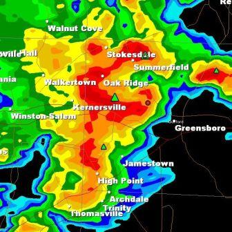
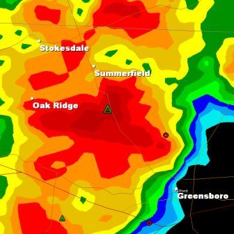
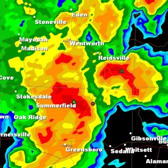
Being but a screen shot the storm markers aren't interactive...the green triangles indicate hail, and moving over the cursor you can see the potential size...in yesterday's storms aloft, I saw hail as big as 1.5", but the size aloft does not necessarily mean it reached the surface. The little red circle symbolizes rotation aloft in the storm. At the very least that will make for strong surface winds and very heavy precipitation, and at worst could be a precursor for tornadic development. And, as you would suspect, the bright reds indicate torrential downpours and almost suredly lots o' lightning. All cells moved in a northeast direction, basically.
Right on cue, delightfully fresh and cool fall-like weather and temperatures grace us with their presence today through the weekend. You can look forward to the upper 60s for today and the lower 40s Saturday morning in the northern Piedmont, and even cooler in them there Hills. Before you know it, the leaves will start their radiant chameleon dance, making for delightful drives on the backroads. Bring it on!
No comments:
Post a Comment