I'll pass.
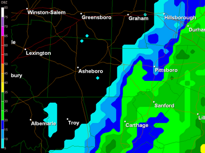
This is a look at the radar around 6am...the rain shield is starting to kiss the Triad market, though much of it is evaporating with only 60% humidites around Graham and Asheboro...and up in the left hand corner of the screen....is sunshine. What is normally 'one' forecast with minor adjustments for western Surry County at times is more accurately 'three' forecasts for the next couple of days...more clouds and showers south and east, more sun breaks and less showers west and north, and then the ol' fudge middleground of mostly cloudy skies and showers starting late today. Winds are just now picking up in the Triad as even this far inland we are looking for the development of steady NNE winds in the 20-25 mph range with gusts near 35 mph.
That's the forecast for the day.
And tonight.
And Wednesday.
And Wednesday night.
Wheeedoggies. NOT.
Looks to be Thursday afternoon before that low takes the brakes off and lurches northward to finally clear us out. Friday's Shopping Mania should have excellent weather for the pre-dawn road warriors, and we'll all enjoy moderating temperatures that climb into the lower 60s for the weekend.
-------------------------------------------------------
As we approach the winter weather season, you'll see us switch over to a type of radar 'expression' which splits precipitation into 'types'. Here is the one this morning of the Carolinas...looks like a goodly band of snow, right? Looks can be and in this case really are deceiving...
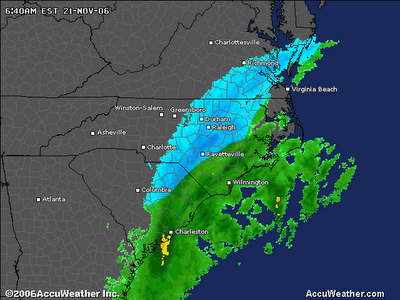
Conditions aloft are certainly cold enough for snow, and that is where the radar is looking...but the surface temperatures are not cold enough to support snow at the surface. With that said, earlier this morning Ft. Bragg and Raleigh reported some light snow mixing in, and even Charleston, SC had a bit of thundersnow...but insofar as widespread snow like the radar shows, it wasn't happening.
And regardless of this type of radar or a non-weather-type radar, just because it may show rain, it does NOT necessarily mean the rain is reaching the ground. As mentioned above, the relative humidites make a huge difference at the surface...the drier the air, the more rain aloft evaporates before it reaches the surface. As the air continues to moisten, then you start developing sprinkles and eventually bona fide showers. So always take radar imagery with a grain of salt...and in my case, check surface observations for more accuracy...which is what I was doing when I forgot to get to the weather wall for the start of my 6:42am weather hit...oopsie...
No comments:
Post a Comment